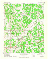
1966 Map of Luther
USGS Topo · Published 1967About this map
Luther serves as the central hub of this mid-1960s landscape, situated at the intersection of significant rail and petroleum infrastructure. The town is flanked by the St Louis-San Francisco and the Missouri-Kansas-Texas railroads, which parallel the course of the Deep Fork river. This era shows an intensive energy landscape, with the Luther Oil and Gas Field, the West Luther Oil and Gas Field, and the South Garden Oil and Gas Field dominating the township. Numerous oil wells and oil wells are scattered throughout the undulating terrain, punctuated by Opossum and Wildhorse Creek. For those researching local families, the map identifies several burial grounds, including Reunion Cem, Luther Cem, St Luke Cem, and Tillman Cem, offering precise locations for genealogical study during a time of expanding transportation via the Turner Toll Road.
Find a feature on this map
43 named features on this map. Tap any name to fly to it.
Don’t see what you’re looking for? This feature index may not catch every label — zoom into the map to look around manually.
Map Details
Editions of this 1966 Luther Map
3 editions found
Other maps of this area

1892 · Guthrie
USGS Topo · 1:62,500

1892 · Edmond
USGS Topo · 1:62,500

1909 · Luther
USGS Topo · 1:62,500

1909 · Perkins
USGS Topo · 1:62,500

1935 · Edmond
USGS Topo · 1:48,000

1940 · Edmond
USGS Topo · 1:62,500

1954 · Oklahoma City
USGS Topo · 1:250,000
1955 · Jones
USGS Topo · 1:24,000

1956 · Horseshoe Lake
USGS Topo · 1:24,000

1957 · Oklahoma City
USGS Topo · 1:250,000