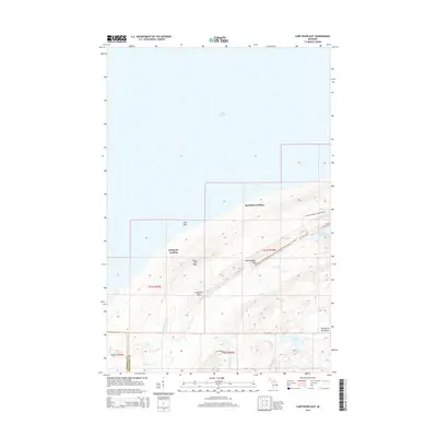
2014 Map of Carp River East
USGS Topo · Published 2014About this map
The Porcupine Mountains dominate this 2014 survey along the shoreline of Lake Superior, where the terrain rises sharply from the water to prominent high points. Distinctive landforms such as Green Mtn Peak, Miscowawbic Peak, and Lafayette Peak provide a topographical frame for the interior river systems, including the Carp River and the Little Carp River. These waterways are punctuated by significant natural features like Shining Cloud Falls and Big Carp Falls as they drain toward the lake.
Find a feature on this map
27 named features on this map. Tap any name to fly to it.
Don’t see what you’re looking for? This feature index may not catch every label — zoom into the map to look around manually.
Map Details
Editions of this 2014 Carp River East Map
This is the sole edition of this map. No revisions or reprints were ever made.
Other maps of this area

1956 · Carp River
USGS Topo · 1:62,500

1956 · Bergland
USGS Topo · 1:62,500

1956 · Thomaston
USGS Topo · 1:62,500

1956 · White Pine
USGS Topo · 1:62,500

1958 · Iron River
USGS Topo · 1:250,000

1960 · Iron River
USGS Topo · 1:250,000

1961 · Iron River
USGS Topo · 1:250,000

1967 · Iron River
USGS Topo · 1:250,000

1979 · Ontonagon
USGS Topo · 1:100,000
1980 · Carp River
USGS Topo · 1:25,000