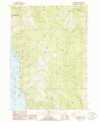
1986 Map of Carpenterville
USGS Topo · Published 1986About this map
Carpenterville sits atop a high ridge overlooking the dramatic meeting of the Pacific coast and the coastal range during the mid-1980s. This survey illustrates a landscape defined by sharp elevation changes and complex drainage systems, where small clearings like Mule Prairie and Rocky Prairie interrupt the timbered slopes. Along the shoreline, the Samuel H Boardman State Park protects geological landmarks such as the Natural Bridges and Whaleshead Rocks, while the Pacific Ocean meets the mainland at the Oregon Islands Wilderness. Inland, the terrain is segmented by deep drainages like Thomas Creek and Whaleshead Creek, which flow west toward the coast, while the eastern portion of the map is dominated by the North Fork Pistol River and the upper reaches of the Chetco River. This period shows a transition between heavy resource extraction and coastal preservation, with the Siskiyou National Forest and various Borrow Pit locations existing alongside established homestead sites like Lane Ranch.
Find a feature on this map
49 named features on this map. Tap any name to fly to it.
Don’t see what you’re looking for? This feature index may not catch every label — zoom into the map to look around manually.
Map Details
Editions of this 1986 Carpenterville Map
This is the sole edition of this map. No revisions or reprints were ever made.
Other maps of this area

1954 · Coos Bay
USGS Topo · 1:250,000

1954 · Cape Ferrelo
USGS Topo · 1:62,500

1954 · Gold Beach
USGS Topo · 1:62,500

1954 · Collier Butte
USGS Topo · 1:62,500

1954 · Mt. Emily
USGS Topo · 1:62,500

1958 · Coos Bay
USGS Topo · 1:250,000

1962 · Coos Bay
USGS Topo · 1:250,000
1985 · Mack Point
USGS Topo · 1:24,000
1986 · Brookings
USGS Topo · 1:24,000
1986 · Sundown Mtn
USGS Topo · 1:24,000