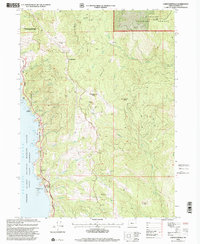
1998 Map of Carpenterville
USGS Topo · Published 2001About this map
Carpenterville sits along a ridgeline in the southern Oregon coastal range, overlooking a landscape where timber and conservation interests meet. In this 1998 revision, the interior is defined by the steep drainages of the South Fork Pistol River and the North Fork Chetco River, flowing through the Siskiyou National Forest. Notable markers of local history include the isolated Joe Foster Camp and a lone Grave north of the primary settlement.
Find a feature on this map
45 named features on this map. Tap any name to fly to it.
Don’t see what you’re looking for? This feature index may not catch every label — zoom into the map to look around manually.
Map Details
Editions of this 1998 Carpenterville Map
This is the sole edition of this map. No revisions or reprints were ever made.
Other maps of this area

1954 · Coos Bay
USGS Topo · 1:250,000

1954 · Cape Ferrelo
USGS Topo · 1:62,500

1954 · Gold Beach
USGS Topo · 1:62,500

1954 · Collier Butte
USGS Topo · 1:62,500

1954 · Mt. Emily
USGS Topo · 1:62,500

1958 · Coos Bay
USGS Topo · 1:250,000

1962 · Coos Bay
USGS Topo · 1:250,000
1985 · Mack Point
USGS Topo · 1:24,000
1986 · Carpenterville
USGS Topo · 1:24,000
1986 · Brookings
USGS Topo · 1:24,000