
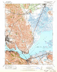
1940 Map of Carquinez Strait
USGS Topo · Published 1963About this map
Carquinez Strait serves as the industrial and maritime artery of this landscape, connecting the waters of Suisun Bay to the Vallejo waterfront. The map captures a high-density transit corridor where the Southern Pacific and Sacramento Northern railroads converge near the water's edge. This 1940 revision, based on Air Corps photography, documents the region before the massive post-war suburban expansion. Maritime infrastructure is prominent, from the Toll Bridge Carquinez Bridge to the Benicia Auto Ferry route crossing toward Martinez. The land use is varied, showing the Benicia S R A Camp and Blue Rock Springs Park alongside industrial outposts like Port Costa, Crockett, and the petroleum-associated docks at Avon. Inland, the terrain rises sharply toward Sulphur Springs Mountain and Elkhorn Peak, contrasting with the intricate network of tidal channels like Suisun Slough and Montezuma Slough that define Joice Island and Grizzly Island.
Find a feature on this map
78 named features on this map. Tap any name to fly to it.
Don’t see what you’re looking for? This feature index may not catch every label — zoom into the map to look around manually.
Map Details
Editions of this 1940 Carquinez Strait Map
2 editions found
Other maps of this area

1895 · San Francisco
USGS Topo · 1:62,500

1896 · Carquinez Strait
USGS Topo · 1:62,500

1896 · Mt. Diablo
USGS Topo · 1:62,500

1897 · Concord
USGS Topo · 1:62,500

1898 · Karquines
USGS Topo · 1:62,500

1898 · Mt. Diablo
USGS Topo · 1:62,500

1899 · San Francisco
USGS Topo · 1:62,500

1901 · Karquines
USGS Topo · 1:62,500

1902 · Napa
USGS Topo · 1:125,000

1907 · Antioch
USGS Topo · 1:62,500