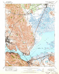
1940 Map of Carquinez Strait
USGS Topo · Published 1965About this map
The confluence of the Sacramento and San Joaquin river systems is dominated here by the deep-water passage of the Carquinez Strait and the marshlands of Suisun Bay. Industrial and maritime hubs like Vallejo, Benicia, and Martinez anchor the shorelines, connected by the Toll Bridge Carquinez Bridge and a network of Southern Pacific rail lines. The landscape transitions sharply from the rugged heights of Sulphur Springs Mountain to the intricate tidal sloughs surrounding Joice Island and Grizzly Island.
Find a feature on this map
91 named features on this map. Tap any name to fly to it.
Don’t see what you’re looking for? This feature index may not catch every label — zoom into the map to look around manually.
Map Details
Editions of this 1940 Carquinez Strait Map
2 editions found

Other maps of this area

1895 · San Francisco
USGS Topo · 1:62,500

1896 · Carquinez Strait
USGS Topo · 1:62,500

1896 · Mt. Diablo
USGS Topo · 1:62,500

1897 · Concord
USGS Topo · 1:62,500

1898 · Karquines
USGS Topo · 1:62,500

1898 · Mt. Diablo
USGS Topo · 1:62,500

1899 · San Francisco
USGS Topo · 1:62,500

1901 · Karquines
USGS Topo · 1:62,500

1902 · Napa
USGS Topo · 1:125,000

1907 · Antioch
USGS Topo · 1:62,500