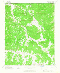
1963 Map of Carracas Canyon
USGS Topo · Published 1967About this map
Carracas Mesa and the surrounding high country define this rugged boundary zone where Rio Arriba County meets the Colorado state line. The map captures a landscape shaped by significant jurisdictional lines, showing where the Carson National Forest meets the Jicarilla Apache Indian Reservation. Along the northern edge, the small settlement of Carracas is visible near the Carracas Cem, served by the winding Carracas Road. The terrain is deeply incised by a network of drainage systems, including Carracas Canyon and Cañon Bancos. These canyons provide natural corridors through the mesa land, punctuated by isolated water sources such as Toro Spring and Vallo Spring. Higher elevations are marked by landmarks like Frijoles Peak and the expansive Los Cuates Basin, while recreational traces appear at the Buzzard Park Campground tucked away in the southern reaches.
Find a feature on this map
37 named features on this map. Tap any name to fly to it.
Don’t see what you’re looking for? This feature index may not catch every label — zoom into the map to look around manually.
Map Details
Editions of this 1963 Carracas Canyon Map
3 editions found
Other maps of this area

1889 · Largo
USGS Topo · 1:250,000

1895 · Largo
USGS Topo · 1:250,000

1924 · Pagosa Springs
USGS Topo · 1:125,000

1927 · Pagosa Springs
USGS Topo · 1:125,000

1945 · Durango
USGS Topo · 1:250,000

1953 · Durango
USGS Topo · 1:250,000

1954 · Durango
USGS Topo · 1:250,000

1954 · Carracas
USGS Topo · 1:24,000

1954 · Aztec
USGS Topo · 1:250,000

1957 · Pagosa Junction
USGS Topo · 1:62,500