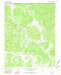
1963 Map of Carracas Canyon
USGS Topo · Published 1983About this map
Carracas Canyon and its complex network of seasonal drainages define this high-desert landscape on the border of New Mexico and Colorado. The terrain is divided by significant administrative boundaries, with the western portion falling under the Carson National Forest and the eastern reaches belonging to the Jicarilla Apache Indian Reservation. Human activity in this remote area is marked by essential water sources like Vallo Spring, Butler Spring, and Toro Spring, which served local ranchers and travelers. Evidence of early industry and settlement appears at the Bancos Pits and the Carracas Cem, while landmarks such as Frijoles Peak and Mesa Bancos provide clear navigational markers across the broken canyon country. The map also traces a lone Gas Well and the winding Carracas Mesa Rd, highlighting the region's sparse infrastructure and reliance on traditional trails and modern resource extraction.
Find a feature on this map
42 named features on this map. Tap any name to fly to it.
Don’t see what you’re looking for? This feature index may not catch every label — zoom into the map to look around manually.
Map Details
Editions of this 1963 Carracas Canyon Map
3 editions found
Other maps of this area

1889 · Largo
USGS Topo · 1:250,000

1895 · Largo
USGS Topo · 1:250,000

1924 · Pagosa Springs
USGS Topo · 1:125,000

1927 · Pagosa Springs
USGS Topo · 1:125,000

1945 · Durango
USGS Topo · 1:250,000

1953 · Durango
USGS Topo · 1:250,000

1954 · Durango
USGS Topo · 1:250,000

1954 · Carracas
USGS Topo · 1:24,000

1954 · Aztec
USGS Topo · 1:250,000

1957 · Pagosa Junction
USGS Topo · 1:62,500