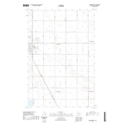
2020 Map of Carrington East
USGS Topo · Published 2020About this map
Carrington serves as the focal point of this Foster County landscape, situated where the high plains meet a grid of section lines and township boundaries. The 2020 layout shows the town's expansion along Main St and its surrounding residential streets, including 8th Ave N and 7th Ave N. Just northwest of the town center lies the Carrington Cem, a significant site for local genealogical research. The surrounding terrain is defined by the Public Land Survey System, with boundaries such as T146n R66w and T146n R65w marking the agricultural allotments that characterize this part of North Dakota. A network of rural routes like 67th Ave NE and 5th St NE connect the scattered farmsteads to the commercial hub of the county.
Find a feature on this map
34 named features on this map. Tap any name to fly to it.
Don’t see what you’re looking for? This feature index may not catch every label — zoom into the map to look around manually.
Map Details
Editions of this 2020 Carrington East Map
This is the sole edition of this map. No revisions or reprints were ever made.
Other maps of this area

1900 · Pingree
USGS Topo · 1:125,000

1944 · Brantford
USGS Topo · 1:62,500

1946 · Brantford
USGS Topo · 1:62,500

1948 · New Rockford
USGS Topo · 1:62,500

1948 · Carrington
USGS Topo · 1:62,500

1950 · Carrington East
USGS Topo · 1:24,000

1950 · Melville
USGS Topo · 1:24,000

1950 · Brantford
USGS Topo · 1:24,000
1950 · New Rockford SE
USGS Topo · 1:24,000

1950 · Barlow
USGS Topo · 1:24,000