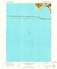
1969 Map of Carrington Island NE
USGS Topo · Published 1972About this map
The Southern Pacific (Lucin Cutoff) dominates this 1969 orthophotomap, showing the railroad's straight path across the open waters of the Great Salt Lake. This engineering marvel, shown here during a period when the lake reached an elevation of 4193 feet, provides a vital rail link across the salt desert. The map captures the industrial character of the crossing, including a bridge structure and survey markers like Lucin BM 4210 and BM 4207.
Find a feature on this map
9 named features on this map. Tap any name to fly to it.
Don’t see what you’re looking for? This feature index may not catch every label — zoom into the map to look around manually.
Map Details
Editions of this 1969 Carrington Island NE Map
This is the sole edition of this map. No revisions or reprints were ever made.
Other maps of this area

1954 · Brigham City
USGS Topo · 1:250,000

1958 · Brigham City
USGS Topo · 1:250,000

1962 · Brigham City
USGS Topo · 1:250,000

1968 · Indian Cove
USGS Topo · 1:24,000

1968 · Pokes Point
USGS Topo · 1:24,000

1968 · Promontory Point
USGS Topo · 1:24,000

1968 · Carrington Island SW
USGS Topo · 1:24,000

1968 · Fremont Island SW
USGS Topo · 1:24,000

1968 · Carrington Island
USGS Topo · 1:24,000

1969 · Rozel Point SW
USGS Topo · 1:24,000