
1968 Map of Pokes Point
USGS Topo · Published 1970About this map
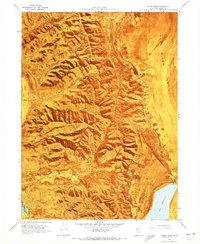
The Promontory Mountains dominate this landscape along the edge of Bear River Bay, where the high desert terrain of northern Utah meets the expansive mud flats of the Great Salt Lake. Surveyed in the late 1960s, the map reveals a remote environment shaped by sparse water sources and industrial extraction. Numerous springs, including Shaw Spring and several unnamed salt springs, emerge at the base of the mountains, while the eastern shoreline is defined by a large Salt Evaporator near Pokes Point. Evidence of localized industry is found in the Gravel Pit and Quarry located in the south, while the Little Valley Harbor and a nearby Gaging Station indicate the navigational and monitoring infrastructure of the era. The presence of a Jeep Tr winding through Little Valley suggests the difficulty of traversing this shoreline before modern road development.
Find a feature on this map
32 named features on this map. Tap any name to fly to it.
Don’t see what you’re looking for? This feature index may not catch every label — zoom into the map to look around manually.
Map Details
Editions of this 1968 Pokes Point Map
2 editions found
Other maps of this area

1954 · Brigham City
USGS Topo · 1:250,000

1955 · Willard Spur
USGS Topo · 1:24,000

1955 · Mouth of Bear River
USGS Topo · 1:24,000

1955 · Fremont Island
USGS Topo · 1:24,000

1958 · Brigham City
USGS Topo · 1:250,000

1962 · Brigham City
USGS Topo · 1:250,000

1967 · East Promontory
USGS Topo · 1:24,000

1968 · Messix Peak
USGS Topo · 1:24,000

1968 · Indian Cove
USGS Topo · 1:24,000

1968 · Promontory Point
USGS Topo · 1:24,000