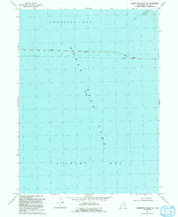
1991 Map of Carrington Island NE
USGS Topo · Published 1991About this map
Gunnison Bay and Gilbert Bay meet in this 1991 survey of the northern Great Salt Lake, where the industrial legacy of the Southern Pacific Railroad dominates the aquatic landscape. The Lucin Cutoff forms a prominent east-west line across the water, including a central Bridge and sections marked as Abandoned. This engineering feat fundamentally altered the lake's hydrology, creating distinct brine environments on either side of the causeway. The map also delineates a Ship Channel to the north and notes the lake's elevation at 4200 feet, providing a technical snapshot of the shoreline and maritime infrastructure before further modern shifts in lake levels. This edition was compiled from 1966 aerial photography with revisions from 1987, documenting the persistent footprint of the railroad in a landscape defined by salt and water.
Find a feature on this map
8 named features on this map. Tap any name to fly to it.
Don’t see what you’re looking for? This feature index may not catch every label — zoom into the map to look around manually.
Map Details
Editions of this 1991 Carrington Island NE Map
This is the sole edition of this map. No revisions or reprints were ever made.
Other maps of this area

1954 · Brigham City
USGS Topo · 1:250,000

1958 · Brigham City
USGS Topo · 1:250,000

1962 · Brigham City
USGS Topo · 1:250,000

1968 · Indian Cove
USGS Topo · 1:24,000

1968 · Pokes Point
USGS Topo · 1:24,000

1968 · Promontory Point
USGS Topo · 1:24,000

1968 · Carrington Island SW
USGS Topo · 1:24,000

1968 · Fremont Island SW
USGS Topo · 1:24,000

1968 · Carrington Island
USGS Topo · 1:24,000

1969 · Rozel Point SW
USGS Topo · 1:24,000