
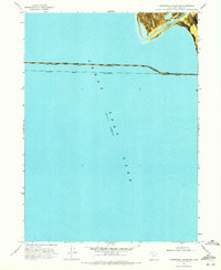
1969 Map of Carrington Island NW
USGS Topo · Published 1972About this map
Great Salt Lake dominates this 1969 orthophotomap, which documents a precise moment in the lake's fluctuating hydrology with an recorded elevation of 4,193 feet. The most prominent human intervention is the Southern Pacific (Lucin Cutoff), a monumental railroad causeway that bisects the open water. This engineering feat, which replaced the longer route around the north end of the lake, includes the small station or operations point of Midlake situated directly on the line. The orthophotomap format provides a literal view of the causeway's construction and its interaction with the surrounding water, showing how the railroad transformed this remote salt desert environment into a critical corridor for transcontinental transit.
Find a feature on this map
4 named features on this map. Tap any name to fly to it.
Don’t see what you’re looking for? This feature index may not catch every label — zoom into the map to look around manually.
Map Details
Editions of this 1969 Carrington Island NW Map
This is the sole edition of this map. No revisions or reprints were ever made.
Other maps of this area

1954 · Brigham City
USGS Topo · 1:250,000

1958 · Brigham City
USGS Topo · 1:250,000

1962 · Brigham City
USGS Topo · 1:250,000

1968 · Indian Cove
USGS Topo · 1:24,000

1968 · Carrington Island SW
USGS Topo · 1:24,000

1968 · Deardens Knoll
USGS Topo · 1:24,000

1968 · Carrington Island
USGS Topo · 1:24,000

1969 · Rozel Point SW
USGS Topo · 1:24,000

1969 · Gunnison Island
USGS Topo · 1:24,000
1969 · Carrington Island NE
USGS Topo · 1:24,000