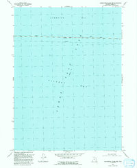
1991 Map of Carrington Island NW
USGS Topo · Published 1991About this map
Great Salt Lake dominates this 1991 revision, where the expansive waters are divided into Gunnison Bay and Gilbert Bay. The map captures the critical east-west transit corridor across the water, defined by the engineering feat of the Lucin Cutoff. A notable historical detail is the inclusion of an Abandoned rail line running parallel to the active cutoff, marking the evolution of this high-desert crossing.
Find a feature on this map
7 named features on this map. Tap any name to fly to it.
Don’t see what you’re looking for? This feature index may not catch every label — zoom into the map to look around manually.
Map Details
Editions of this 1991 Carrington Island NW Map
This is the sole edition of this map. No revisions or reprints were ever made.
Other maps of this area

1954 · Brigham City
USGS Topo · 1:250,000

1958 · Brigham City
USGS Topo · 1:250,000

1962 · Brigham City
USGS Topo · 1:250,000

1968 · Indian Cove
USGS Topo · 1:24,000

1968 · Carrington Island SW
USGS Topo · 1:24,000

1968 · Deardens Knoll
USGS Topo · 1:24,000

1968 · Carrington Island
USGS Topo · 1:24,000

1969 · Rozel Point SW
USGS Topo · 1:24,000

1969 · Carrington Island NW
USGS Topo · 1:24,000

1969 · Gunnison Island
USGS Topo · 1:24,000