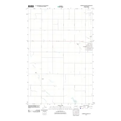
2011 Map of Carrington West
USGS Topo · Published 2011About this map
Carrington serves as the primary hub of this eastern North Dakota landscape, organized by a precise grid of rural avenues and township roads. The settlement's western edge is defined by Matheny Field, while the local history of the community is anchored by the Carrington Cemetery situated northeast of the main residential streets. The hydrology of the region is dominated by the winding course of Pipestem Creek, which flows southeastward toward Little Pipestem Creek. This 2011 survey reveals a transition from the structured street plan of the town to the open prairie and slough country characteristic of Foster County. Smaller water bodies like Scotts Slough and Russell Lake dot the agricultural plains, alongside man-made infrastructure like the Wyard Dam and the more remote Longview Cemetery, providing a detailed view of the area's development and land use in the early 21st century.
Find a feature on this map
46 named features on this map. Tap any name to fly to it.
Don’t see what you’re looking for? This feature index may not catch every label — zoom into the map to look around manually.
Map Details
Editions of this 2011 Carrington West Map
This is the sole edition of this map. No revisions or reprints were ever made.
Other maps of this area

1948 · New Rockford
USGS Topo · 1:62,500

1948 · Cathay
USGS Topo · 1:62,500

1948 · Carrington
USGS Topo · 1:62,500

1949 · Cathay SE
USGS Topo · 1:24,000

1950 · Carrington East
USGS Topo · 1:24,000

1950 · Melville
USGS Topo · 1:24,000
1950 · New Rockford SE
USGS Topo · 1:24,000

1950 · Barlow
USGS Topo · 1:24,000

1950 · Carrington SW
USGS Topo · 1:24,000

1950 · Carrington West
USGS Topo · 1:24,000