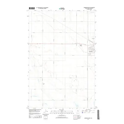
2014 Map of Carrington West
USGS Topo · Published 2014About this map
Carrington sits at the eastern edge of this landscape, a prairie hub where the grid of city streets meets the wide agricultural expanse of Foster County. The town layout is clearly defined by early thoroughfares including Main St and 11th St N, while the local infrastructure is supported by the Carrington Municipal Airport. Outside the settlement, the terrain is shaped by the wandering paths of Pipestem Cr and Little Pipestem Cr, which drain into localized basins like Russell Lake. For those tracing family histories, the map identifies two significant burial grounds: the Carrington Cem near the northern town limits and the Longview Cem situated further south among the section lines. The presence of Scotts Slough in the northeast corner further illustrates the glacial depression topography characteristic of this part of North Dakota.
Find a feature on this map
23 named features on this map. Tap any name to fly to it.
Don’t see what you’re looking for? This feature index may not catch every label — zoom into the map to look around manually.
Map Details
Editions of this 2014 Carrington West Map
This is the sole edition of this map. No revisions or reprints were ever made.
Other maps of this area

1948 · New Rockford
USGS Topo · 1:62,500

1948 · Cathay
USGS Topo · 1:62,500

1948 · Carrington
USGS Topo · 1:62,500

1949 · Cathay SE
USGS Topo · 1:24,000

1950 · Carrington East
USGS Topo · 1:24,000

1950 · Melville
USGS Topo · 1:24,000
1950 · New Rockford SE
USGS Topo · 1:24,000

1950 · Barlow
USGS Topo · 1:24,000

1950 · Carrington SW
USGS Topo · 1:24,000

1950 · Carrington West
USGS Topo · 1:24,000