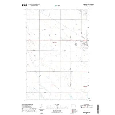
2018 Map of Carrington West
USGS Topo · Published 2018About this map
Carrington anchors the eastern edge of this landscape, where the residential and commercial grid transitions into the sprawling agricultural tracts of t146n r66w and t145n r66w. The local transport network is defined by a series of numbered section-line roads, including Main St E and 5th St NE, which facilitate movement between the town center and the surrounding fields. The prairie geography is marked by several significant water features, including the winding course of Pipestem Cr and its tributary Little Pipestem Cr in the southwest, while Russell Lake and Scotts Slough occupy the lower-lying depressions in the terrain.
Find a feature on this map
29 named features on this map. Tap any name to fly to it.
Don’t see what you’re looking for? This feature index may not catch every label — zoom into the map to look around manually.
Map Details
Editions of this 2018 Carrington West Map
This is the sole edition of this map. No revisions or reprints were ever made.
Other maps of this area

1948 · New Rockford
USGS Topo · 1:62,500

1948 · Cathay
USGS Topo · 1:62,500

1948 · Carrington
USGS Topo · 1:62,500

1949 · Cathay SE
USGS Topo · 1:24,000

1950 · Carrington East
USGS Topo · 1:24,000

1950 · Melville
USGS Topo · 1:24,000
1950 · New Rockford SE
USGS Topo · 1:24,000

1950 · Barlow
USGS Topo · 1:24,000

1950 · Carrington SW
USGS Topo · 1:24,000

1950 · Carrington West
USGS Topo · 1:24,000