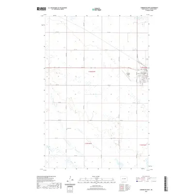
2020 Map of Carrington West
USGS Topo · Published 2020About this map
Carrington serves as the focal point of this Foster County landscape, situated where the central plains transition into a mosaic of wetlands and small water bodies. The town's grid is anchored by the Foster County Court House and extends toward the Carrington Municipal Airport to the west. Outside the city limits, the terrain is defined by a complex drainage system, featuring the meandering Pipestem Cr and Little Pipestem Cr which flow through the southwestern sections. For those researching local family history, the Riverdale Cem is a significant landmark located west of the main settlement. The presence of Russell Lake and Scotts Slough reflects the glacial topography typical of this region, creating a distinctive pattern of prairie potholes and seasonal water features that dictate the layout of the section lines and rural road network.
Find a feature on this map
29 named features on this map. Tap any name to fly to it.
Don’t see what you’re looking for? This feature index may not catch every label — zoom into the map to look around manually.
Map Details
Editions of this 2020 Carrington West Map
This is the sole edition of this map. No revisions or reprints were ever made.
Other maps of this area

1948 · New Rockford
USGS Topo · 1:62,500

1948 · Cathay
USGS Topo · 1:62,500

1948 · Carrington
USGS Topo · 1:62,500

1949 · Cathay SE
USGS Topo · 1:24,000

1950 · Carrington East
USGS Topo · 1:24,000

1950 · Melville
USGS Topo · 1:24,000
1950 · New Rockford SE
USGS Topo · 1:24,000

1950 · Barlow
USGS Topo · 1:24,000

1950 · Carrington SW
USGS Topo · 1:24,000

1950 · Carrington West
USGS Topo · 1:24,000