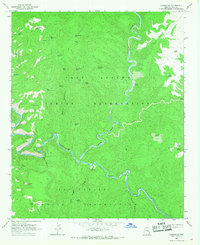
1966 Map of Carrizo SE
USGS Topo · Published 1968About this map
The Salt River carves a deep path across this mid-1960s survey, marking the boundary between the Fort Apache Indian Reservation and the San Carlos Indian Reservation. This landscape is defined by its drainage systems and isolated landmarks, notably where Carrizo Creek and Cedar Creek join the river from the north. The high ground is punctuated by distinct formations such as Bull Butte and Cowboy Butte, while the drainage of Popcorn Canyon feeds in from the south.
Find a feature on this map
43 named features on this map. Tap any name to fly to it.
Don’t see what you’re looking for? This feature index may not catch every label — zoom into the map to look around manually.
Map Details
Editions of this 1966 Carrizo SE Map
This is the sole edition of this map. No revisions or reprints were ever made.
Other maps of this area

1954 · Mesa
USGS Topo · 1:250,000

1957 · Mesa
USGS Topo · 1:250,000

1958 · Mesa
USGS Topo · 1:250,000

1960 · Mesa
USGS Topo · 1:250,000

1964 · Mesa
USGS Topo · 1:250,000

1966 · Brushy Canyon
USGS Topo · 1:24,000

1966 · Popcorn Canyon
USGS Topo · 1:24,000
1966 · Forks Butte
USGS Topo · 1:24,000
1966 · Carrizo
USGS Topo · 1:24,000
1966 · Cone Butte
USGS Topo · 1:24,000