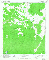
1966 Map of Cone Butte
USGS Topo · Published 1968About this map
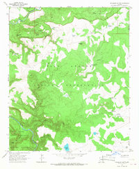
The Fort Apache Indian Reservation and San Carlos Indian Reservation divide this high-desert landscape in the mid-1960s, defined by a complex network of seasonal springs, gaging stations, and livestock watering tanks. The topography is dominated by the namesake Cone Butte and the rugged drainage of Cedar Creek, which is bridged at the Cedar Creek Crossing. This era of land management is evidenced by the numerous named water sources such as Bad Luck Spring, Wild Bull Spring, and Trailer House Spring, alongside infrastructure like the R-14 Ranch and several Diversion Dams. The map captures a transition in water management, showing both natural Seasonal Springs and constructed catchments like Cemetery Tank, Apache Pond No 1, and Sam Green Tank, reflecting the vital importance of water rights and livestock grazing across these reservation lands.
Find a feature on this map
59 named features on this map. Tap any name to fly to it.
Don’t see what you’re looking for? This feature index may not catch every label — zoom into the map to look around manually.
Map Details
Editions of this 1966 Cone Butte Map
This is the sole edition of this map. No revisions or reprints were ever made.
Other maps of this area

1954 · Mesa
USGS Topo · 1:250,000

1957 · Mesa
USGS Topo · 1:250,000

1958 · Mesa
USGS Topo · 1:250,000

1960 · Mesa
USGS Topo · 1:250,000

1964 · Mesa
USGS Topo · 1:250,000

1966 · Popcorn Canyon
USGS Topo · 1:24,000
1966 · Forks Butte
USGS Topo · 1:24,000
1966 · Round Top Mtn
USGS Topo · 1:24,000
1966 · Carrizo
USGS Topo · 1:24,000
1966 · Velasquez Butte
USGS Topo · 1:24,000