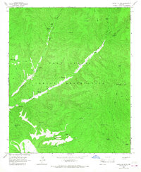
1966 Map of Round Top Mtn
USGS Topo · Published 1967About this map
The Fort Apache Indian Reservation defines this 1960s landscape, illustrating a complex network of water management and livestock infrastructure across the Arizona high country. The terrain is marked by significant topographical features such as Round Top Mtn and the prominent Lake Ridge. Water sources are the primary identifiers here, with numerous named tanks and springs like G-5 Farm Spring, Steer Pasture Spring, and Coyote Tank supporting local ranching operations. The drainage patterns of Canyon Creek and East Big Cedar Creek dictate the movement of travel, as indicated by the various jeep and pack trails crossing the county line between Gila and Navajo. Notable landmarks like the 85 Bar Spring and the Gravel Pit near the eastern boundary offer specific points of interest for those studying historical land use and the development of the reservation's resources during the mid-20th century.
Find a feature on this map
37 named features on this map. Tap any name to fly to it.
Don’t see what you’re looking for? This feature index may not catch every label — zoom into the map to look around manually.
Map Details
Editions of this 1966 Round Top Mtn Map
This is the sole edition of this map. No revisions or reprints were ever made.
Other maps of this area

1886 · St Johns
USGS Topo · 1:250,000

1886 · Holbrook
USGS Topo · 1:250,000

1892 · St Johns
USGS Topo · 1:250,000

1893 · Holbrook
USGS Topo · 1:250,000

1954 · Holbrook
USGS Topo · 1:250,000

1954 · Clifton
USGS Topo · 1:250,000

1954 · Saint Johns
USGS Topo · 1:250,000

1954 · Mesa
USGS Topo · 1:250,000

1957 · Mesa
USGS Topo · 1:250,000

1957 · Holbrook
USGS Topo · 1:250,000