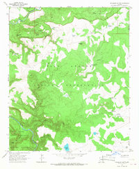
1966 Map of Velasquez Butte
USGS Topo · Published 1968About this map
The boundary between the Fort Apache Indian Reservation and the San Carlos Indian Reservation follows the winding course of the Black River through the southern portion of this mid-1960s study. The landscape is defined by the massive Seven Mile Rim to the north and the Natanes Plateau rising in the southwest. Between these high points, the terrain is a complex network of canyons and flats, where water management is critical to the local economy. A series of livestock tanks and springs, such as Velasquez Butte Tank No 2, Pit Hole Tank, and Navajo Bill Spring, are connected by a web of jeep trails and fence lines. This infrastructure suggests a landscape primarily dedicated to cattle grazing on tribal lands, with remote outposts like Lower Camp Tank serving as markers of human activity in the high desert of Gila and Navajo counties.
Find a feature on this map
39 named features on this map. Tap any name to fly to it.
Don’t see what you’re looking for? This feature index may not catch every label — zoom into the map to look around manually.
Map Details
Editions of this 1966 Velasquez Butte Map
This is the sole edition of this map. No revisions or reprints were ever made.
Other maps of this area

1954 · Clifton
USGS Topo · 1:250,000

1954 · Mesa
USGS Topo · 1:250,000

1957 · Mesa
USGS Topo · 1:250,000

1957 · Clifton
USGS Topo · 1:250,000

1958 · Clifton
USGS Topo · 1:250,000

1958 · Mesa
USGS Topo · 1:250,000

1960 · Mesa
USGS Topo · 1:250,000

1962 · Clifton
USGS Topo · 1:250,000

1964 · Mesa
USGS Topo · 1:250,000

1966 · Georges Butte
USGS Topo · 1:24,000