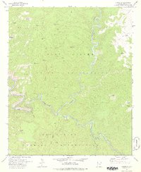
1978 Map of Carrizo SE
USGS Topo · Published 1978About this map
The confluence of Carrizo Creek and the Salt River forms the geographic heart of this high-desert landscape, captured during a 1978 revision of 1960s photogrammetric data. This map documents the boundary between the Fort Apache Indian Reservation and the San Carlos Indian Reservation, revealing a terrain defined by deep drainage systems like Abdoul Canyon and Alkali Canyon.
Find a feature on this map
41 named features on this map. Tap any name to fly to it.
Don’t see what you’re looking for? This feature index may not catch every label — zoom into the map to look around manually.
Map Details
Editions of this 1978 Carrizo SE Map
This is the sole edition of this map. No revisions or reprints were ever made.
Other maps of this area

1954 · Mesa
USGS Topo · 1:250,000

1957 · Mesa
USGS Topo · 1:250,000

1958 · Mesa
USGS Topo · 1:250,000

1960 · Mesa
USGS Topo · 1:250,000

1964 · Mesa
USGS Topo · 1:250,000

1966 · Brushy Canyon
USGS Topo · 1:24,000

1966 · Popcorn Canyon
USGS Topo · 1:24,000
1966 · Forks Butte
USGS Topo · 1:24,000
1966 · Carrizo
USGS Topo · 1:24,000
1966 · Cone Butte
USGS Topo · 1:24,000