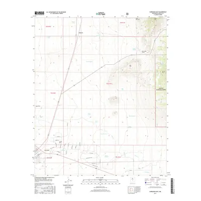
2017 Map of Carrizozo East
USGS Topo · Published 2017About this map
Carrizozo serves as the primary hub in this arid landscape where the high desert meets the slopes of Carrizo Mtn and Baxter Mtn. The town’s residential grid, featuring streets like 12th St and Birch St, is defined by its proximity to vital water sources such as Carrizozo Spring. To the north, the small settlement of Robsart sits along the road, while the terrain transitions into the protected highlands of the Lincoln National Forest. The landscape is dotted with named windmills like Mayer Windmill and Nickles Windmill, highlighting the essential infrastructure required for ranching and survival in this portion of Lincoln County. Deep drainage features, including White Oaks Canyon and Nogal Draw, trace the natural path of seasonal water through the rugged Bald Hills.
Find a feature on this map
47 named features on this map. Tap any name to fly to it.
Don’t see what you’re looking for? This feature index may not catch every label — zoom into the map to look around manually.
Map Details
Editions of this 2017 Carrizozo East Map
This is the sole edition of this map. No revisions or reprints were ever made.
Other maps of this area

1934 · Capitan
USGS Topo · 1:48,000

1937 · Capitan
USGS Topo · 1:62,500

1938 · Carrizozo
USGS Topo · 1:48,000

1943 · Carrizozo
USGS Topo · 1:62,500

1950 · Carrizozo
USGS Topo · 1:62,500

1950 · Little Black Peak
USGS Topo · 1:62,500

1955 · Roswell
USGS Topo · 1:250,000

1958 · Roswell
USGS Topo · 1:250,000

1962 · Roswell
USGS Topo · 1:250,000
1973 · Nogal
USGS Topo · 1:24,000