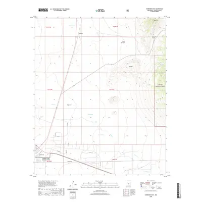
2020 Map of Carrizozo East
USGS Topo · Published 2020About this map
The town of Carrizozo sits at the southwestern edge of this landscape, where the high desert floor meets the rising slopes of Carrizo Mtn. This survey details a transition from the structured street grid of the settlement to the open drainage systems of the Tularosa Basin, including Lemon Draw and Nogal Draw. To the northeast, the topography becomes increasingly complex as it enters the Lincoln National Forest, reaching the heights of Baxter Mtn and the prominent Bald Hills. Local water sources like Carrizozo Spring, Fetters Spring, and the Bonito Lake System Annex illustrate the critical nature of water management in this arid Lincoln County environment. A network of rural routes such as Possum Trl and Whistler Trl connect scattered sites like Robsart, showing the modern connectivity between the valley floor and the canyons of the Sacramento Mountains.
Find a feature on this map
36 named features on this map. Tap any name to fly to it.
Don’t see what you’re looking for? This feature index may not catch every label — zoom into the map to look around manually.
Map Details
Editions of this 2020 Carrizozo East Map
This is the sole edition of this map. No revisions or reprints were ever made.
Other maps of this area

1934 · Capitan
USGS Topo · 1:48,000

1937 · Capitan
USGS Topo · 1:62,500

1938 · Carrizozo
USGS Topo · 1:48,000

1943 · Carrizozo
USGS Topo · 1:62,500

1950 · Carrizozo
USGS Topo · 1:62,500

1950 · Little Black Peak
USGS Topo · 1:62,500

1955 · Roswell
USGS Topo · 1:250,000

1958 · Roswell
USGS Topo · 1:250,000

1962 · Roswell
USGS Topo · 1:250,000
1973 · Nogal
USGS Topo · 1:24,000