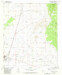
1982 Map of Carrizozo East
USGS Topo · Published 1982About this map
The town of Carrizozo serves as a critical junction on this 1982 survey, where the Southern Pacific railroad cuts a diagonal line across the high desert floor. The landscape is defined by its water management, evidenced by a vast network of family and locally named infrastructure such as Mayer Windmill, Fetters Spring, and Dugger Well. These sites reveal the precarious balance of ranching and habitation in the arid environment surrounding Nogal Draw and White Oaks Draw.
Find a feature on this map
36 named features on this map. Tap any name to fly to it.
Don’t see what you’re looking for? This feature index may not catch every label — zoom into the map to look around manually.
Map Details
Editions of this 1982 Carrizozo East Map
This is the sole edition of this map. No revisions or reprints were ever made.
Other maps of this area

1934 · Capitan
USGS Topo · 1:48,000

1937 · Capitan
USGS Topo · 1:62,500

1938 · Carrizozo
USGS Topo · 1:48,000

1943 · Carrizozo
USGS Topo · 1:62,500

1950 · Carrizozo
USGS Topo · 1:62,500

1950 · Little Black Peak
USGS Topo · 1:62,500

1955 · Roswell
USGS Topo · 1:250,000

1958 · Roswell
USGS Topo · 1:250,000

1962 · Roswell
USGS Topo · 1:250,000
1973 · Nogal
USGS Topo · 1:24,000