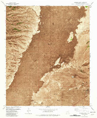
1982 Map of Carrizozo West
USGS Topo · Published 1982About this map
The Malpais dominates this 1982 orthophotomap, showcasing the stark, dark volcanic flows of the Lava fields that define the Tularosa Basin floor. This technical composite combines aerial photography with topographic data to map the harsh geology of Valley of Fires State Park, where the young basalt contrasts sharply with the surrounding desert flats. At the southeastern edge of this volcanic wilderness, the town of Carrizozo sits at the junction of the Southern Pacific railroad and regional roads.
Find a feature on this map
20 named features on this map. Tap any name to fly to it.
Don’t see what you’re looking for? This feature index may not catch every label — zoom into the map to look around manually.
Map Details
Editions of this 1982 Carrizozo West Map
This is the sole edition of this map. No revisions or reprints were ever made.
Other maps of this area

1918 · Oscura Peak
USGS Topo · 1:125,000

1938 · Carrizozo
USGS Topo · 1:48,000

1943 · Carrizozo
USGS Topo · 1:62,500

1948 · Broken Back Crater
USGS Topo · 1:62,500

1948 · Chihuahua Ranch
USGS Topo · 1:62,500

1950 · Carrizozo
USGS Topo · 1:62,500

1950 · Little Black Peak
USGS Topo · 1:62,500

1954 · Tularosa
USGS Topo · 1:250,000

1955 · Roswell
USGS Topo · 1:250,000

1958 · Roswell
USGS Topo · 1:250,000