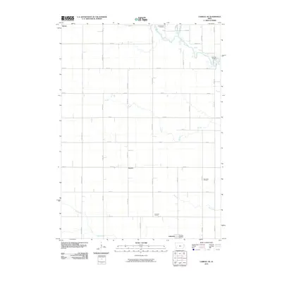
2010 Map of Carroll NE
USGS Topo · Published 2010About this map
Lidderdale anchors the southern portion of this landscape, a region defined by a precise grid of agricultural roads and the wandering course of the North Raccoon River. In the early 21st century, the area maintains a rural character centered around small hubs like the village of Auburn and the Lidderdale Post Office. Genealogists and local historians will find several established burial grounds across the quadrangle, including Cottonwood Cemetery in the north and East Liberty Cemetery to the east. The terrain is marked by a series of drainage systems, most notably Lake Creek, Elk Run, and Storm Creek, which cut through the farm plots. The crossing at Lake City Bridge serves as a key landmark in the northeast, where the river bends sharply, while the smaller settlement area of Kentner provides a point of reference along the central north-south transit lines.
Find a feature on this map
41 named features on this map. Tap any name to fly to it.
Don’t see what you’re looking for? This feature index may not catch every label — zoom into the map to look around manually.
Map Details
Editions of this 2010 Carroll NE Map
This is the sole edition of this map. No revisions or reprints were ever made.
Other maps of this area

1954 · Fort Dodge
USGS Topo · 1:250,000

1957 · Fort Dodge
USGS Topo · 1:250,000

1958 · Fort Dodge
USGS Topo · 1:250,000
1980 · Glidden
USGS Topo · 1:24,000

1980 · Breda
USGS Topo · 1:24,000

1980 · Grant City
USGS Topo · 1:24,000

1980 · Carroll NE
USGS Topo · 1:24,000

1980 · Yetter
USGS Topo · 1:24,000
1980 · Carroll West
USGS Topo · 1:24,000
1980 · Carroll East
USGS Topo · 1:24,000