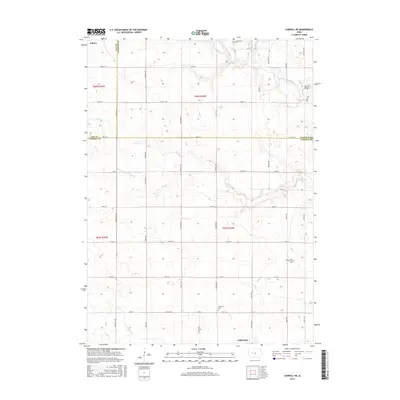
2015 Map of Carroll NE
USGS Topo · Published 2015About this map
The North Raccoon River winds through the northeast corner of this agricultural landscape, where the borders of Sac, Calhoun, and Carroll counties converge. The town of Auburn sits at the northwestern edge, while Lidderdale anchors the southern boundary, connected by a network of rural routes such as Co Rd E17 and Co Rd E26. This survey documents a sophisticated drainage system essential to Iowa farming, featuring Ditch Number 72 and 81 and several local waterways like Elk Run and Buck Run. Genealogists will find three distinct burial sites preserved on this sheet: Cottonwood Cem, East Liberty Cem, and Immanuel Cem. The presence of the Lake City Bridge near the eastern margin further highlights the local infrastructure designed to manage the river valley crossings in this productive corner of the Iowa plains.
Find a feature on this map
33 named features on this map. Tap any name to fly to it.
Don’t see what you’re looking for? This feature index may not catch every label — zoom into the map to look around manually.
Map Details
Editions of this 2015 Carroll NE Map
This is the sole edition of this map. No revisions or reprints were ever made.
Other maps of this area

1954 · Fort Dodge
USGS Topo · 1:250,000

1957 · Fort Dodge
USGS Topo · 1:250,000

1958 · Fort Dodge
USGS Topo · 1:250,000
1980 · Glidden
USGS Topo · 1:24,000

1980 · Breda
USGS Topo · 1:24,000

1980 · Grant City
USGS Topo · 1:24,000

1980 · Carroll NE
USGS Topo · 1:24,000

1980 · Yetter
USGS Topo · 1:24,000
1980 · Carroll West
USGS Topo · 1:24,000
1980 · Carroll East
USGS Topo · 1:24,000