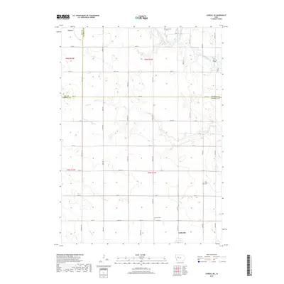
2018 Map of Carroll NE
USGS Topo · Published 2018About this map
Auburn and Lidderdale anchor the northwest and southeast corners of this agricultural landscape, where the borders of Sac, Calhoun, and Carroll Counties meet. The terrain is defined by the winding course of the North Raccoon River in the northeast, which is spanned by the Lake City Bridge near its confluence with Lake Creek. This area shows a highly organized grid of county roads and avenues that segment the productive Iowa prairie, interrupted only by the natural drainage of Elk Run and Buck Run.
Find a feature on this map
51 named features on this map. Tap any name to fly to it.
Don’t see what you’re looking for? This feature index may not catch every label — zoom into the map to look around manually.
Map Details
Editions of this 2018 Carroll NE Map
This is the sole edition of this map. No revisions or reprints were ever made.
Other maps of this area

1954 · Fort Dodge
USGS Topo · 1:250,000
1957 · Fort Dodge
USGS Topo · 1:250,000
1958 · Fort Dodge
USGS Topo · 1:250,000
1980 · Glidden
USGS Topo · 1:24,000
1980 · Breda
USGS Topo · 1:24,000
1980 · Grant City
USGS Topo · 1:24,000
1980 · Carroll NE
USGS Topo · 1:24,000
1980 · Yetter
USGS Topo · 1:24,000
1980 · Carroll West
USGS Topo · 1:24,000
1980 · Carroll East
USGS Topo · 1:24,000