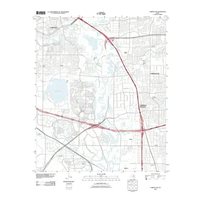
2010 Map of Carrollton
USGS Topo · Published 2010About this map
Elm Fork Trinity River winds through the heart of this North Texas corridor, anchoring a landscape defined by rapid suburban expansion and heavy infrastructure. This 2010 survey illustrates the densely developed intersection of Carrollton, Farmers Branch, and Lewisville. The presence of the President George Bush Pkwy and major rail lines underscores the area's role as a transportation hub, yet traces of an older, rural landscape remain visible in the Harrington Cemetery and Perry Cemetery. Water management is central to the local geography, with the Carrollton Dam and North Lake Dam regulating the flow of the Elm Fork and its tributaries like Denton Creek and Grapevine Creek. From the open spaces of Hackberry Ranch to the industrial and commercial nodes at Gribble and Trinity Mills, the map provides a look at the suburban Dallas-Fort Worth metroplex during a period of significant growth.
Find a feature on this map
69 named features on this map. Tap any name to fly to it.
Don’t see what you’re looking for? This feature index may not catch every label — zoom into the map to look around manually.
Map Details
Editions of this 2010 Carrollton Map
This is the sole edition of this map. No revisions or reprints were ever made.
Other maps of this area

1891 · Dallas
USGS Topo · 1:125,000

1893 · Dallas
USGS Topo · 1:125,000

1894 · Fort Worth
USGS Topo · 1:125,000

1925 · Mc Kinney 3-c
USGS Topo · 1:48,000

1925 · Dallas 2-b
USGS Topo · 1:48,000

1929 · Frisco
USGS Topo · 1:62,500

1931 · Carrollton
USGS Topo · 1:62,500

1931 · Grapevine
USGS Topo · 1:62,500

1954 · Dallas
USGS Topo · 1:250,000

1954 · Sherman
USGS Topo · 1:250,000