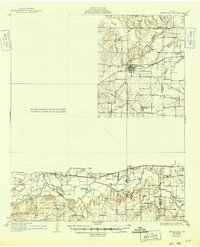
1931 Map of Grapevine
USGS Topo · Published 1931About this map
Grapevine sits at the nexus of several vital North Texas drainage systems in this early 1930s depiction, where the St Louis Southwestern railroad serves as a primary transit artery across the county line. The landscape is defined by the winding course of the Trinity River and its major tributaries, including Denton Creek, Bear Creek, and Fossil Creek. A notable industrial marker is the Randalls Mill and its associated Randalls Mill Dam, which speaks to the early resource-based economy of the Tarrant County region. Local education and community nodes are mapped through rural institutions like Shady Grove Sch, Watson Sch, and John T White Sch. The survey records a period before massive suburban expansion, documenting small settlements like Muriel, Coppell, and Hurst when they were still distinct agricultural or railroad-adjacent hubs.
Find a feature on this map
30 named features on this map. Tap any name to fly to it.
Don’t see what you’re looking for? This feature index may not catch every label — zoom into the map to look around manually.
Map Details
Editions of this 1931 Grapevine Map
2 editions found
Historical Maps of Fort Worth Through Time
4 maps found