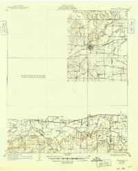
1931 Map of Grapevine
USGS Topo · Published 1949About this map
Grapevine and Coppell anchor the northern reaches of this mid-1920s landscape, a time when the region was defined by its creeks and agricultural transport lines before the era of massive reservoir development. The Trinity River snakes through the southern portion of the sheet, where localized infrastructure like the Randalls Mill Dam and the Bedford Bridge facilitated movement across the bottomlands. This survey, compiled in part from early Air Corps aerial photography, highlights a network of rural schools including the John T White Sch, Watson Sch, and Shady Grove Sch that served the dispersed farming communities.
Find a feature on this map
29 named features on this map. Tap any name to fly to it.
Don’t see what you’re looking for? This feature index may not catch every label — zoom into the map to look around manually.
Map Details
Editions of this 1931 Grapevine Map
2 editions found
Other maps of this area

1891 · Dallas
USGS Topo · 1:125,000

1893 · Dallas
USGS Topo · 1:125,000

1894 · Fort Worth
USGS Topo · 1:125,000

1925 · Mc Kinney 3-c
USGS Topo · 1:48,000

1925 · Dallas 2-b
USGS Topo · 1:48,000

1929 · Frisco
USGS Topo · 1:62,500

1931 · Carrollton
USGS Topo · 1:62,500

1931 · Grapevine
USGS Topo · 1:62,500

1954 · Dallas
USGS Topo · 1:250,000

1954 · Sherman
USGS Topo · 1:250,000