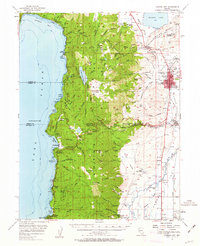
1956 Map of Carson City
USGS Topo · Published 1963About this map
Carson City serves as the focal point of this mid-century survey, revealing the Nevada state capital as it appeared before the significant growth of the late 20th century. The map highlights key institutional landmarks such as the State Capitol, the Carson-Tahoe Hospital, and the Sunny Acres Childrens Home. To the south, the Stewart (Indian Agency) and the historic settlement of Genoa represent the enduring heritage of the Eagle Valley region.
Find a feature on this map
79 named features on this map. Tap any name to fly to it.
Don’t see what you’re looking for? This feature index may not catch every label — zoom into the map to look around manually.
Map Details
Editions of this 1956 Carson City Map
4 editions found

Other maps of this area

1889 · Pyramid Peak
USGS Topo · 1:125,000

1889 · Markleeville
USGS Topo · 1:125,000

1891 · Carson
USGS Topo · 1:125,000

1891 · Markleeville
USGS Topo · 1:125,000

1891 · Truckee
USGS Topo · 1:125,000

1891 · Pyramid Peak
USGS Topo · 1:125,000

1893 · Carson
USGS Topo · 1:125,000

1893 · Markleeville
USGS Topo · 1:125,000

1893 · Truckee
USGS Topo · 1:125,000

1895 · Pyramid Peak
USGS Topo · 1:125,000