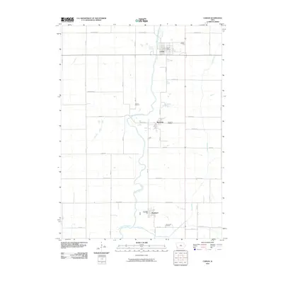
2010 Map of Carson
USGS Topo · Published 2010About this map
The West Nishnabotna River carves a winding path through this corner of Pottawattamie County, anchoring a series of river-valley settlements that include Carson, Macedonia, and Henderson. The 2010 landscape is defined by a rigorous sectional road grid, yet the irregular course of the river and its tributaries, such as Graybill Creek and Farm Creek, dictate the placement of early infrastructure. Genealogists will find significant value in the documentation of several local burial grounds, including the Old Town Cemetery north of Macedonia and the Carson Cemetery situated just east of its namesake town. These sites, along with the Macedonia Cemetery and Farm Creek Cemetery, provide a clear spatial record of the area's rural heritage. The map also pinpoint local centers of community life, specifically the Carson Post Office and Henderson Post Office, which remain essential landmarks in these southwestern Iowa towns.
Find a feature on this map
38 named features on this map. Tap any name to fly to it.
Don’t see what you’re looking for? This feature index may not catch every label — zoom into the map to look around manually.
Map Details
Editions of this 2010 Carson Map
This is the sole edition of this map. No revisions or reprints were ever made.
Other maps of this area

1954 · Omaha
USGS Topo · 1:250,000

1956 · Treynor
USGS Topo · 1:24,000

1956 · Malvern
USGS Topo · 1:24,000

1957 · Omaha
USGS Topo · 1:250,000

1957 · Taylor
USGS Topo · 1:24,000

1958 · Omaha
USGS Topo · 1:250,000

1963 · Avoca SE
USGS Topo · 1:24,000

1963 · Oakland
USGS Topo · 1:24,000

1978 · Carson
USGS Topo · 1:24,000
1978 · Emerson
USGS Topo · 1:24,000