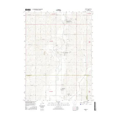
2015 Map of Carson
USGS Topo · Published 2015About this map
Carson and Macedonia anchor this western Iowa landscape where the West Nishnabotna River valley carves through the agricultural uplands. The terrain is marked by a network of drainage systems, including the southward-flowing Graybill Cr and Farm Creek, which define the local topography and settlement patterns. Cultural history is deeply embedded in the road network, notably along the Iowa Mormon Trl and Pioneer Trl, tracing paths of migration and early commerce through Pottawattamie County and into northern Mills County. Local genealogy is well-supported by several burial grounds serving these small communities, such as Carson Cem to the north and the isolated Old Town Cem located between the primary townships. In the south, the village of Henderson sits near the confluence of local tributaries, illustrating the enduring relationship between these prairie settlements and their water sources.
Find a feature on this map
38 named features on this map. Tap any name to fly to it.
Don’t see what you’re looking for? This feature index may not catch every label — zoom into the map to look around manually.
Map Details
Editions of this 2015 Carson Map
This is the sole edition of this map. No revisions or reprints were ever made.
Other maps of this area

1954 · Omaha
USGS Topo · 1:250,000

1956 · Treynor
USGS Topo · 1:24,000

1956 · Malvern
USGS Topo · 1:24,000

1957 · Omaha
USGS Topo · 1:250,000

1957 · Taylor
USGS Topo · 1:24,000

1958 · Omaha
USGS Topo · 1:250,000

1963 · Avoca SE
USGS Topo · 1:24,000

1963 · Oakland
USGS Topo · 1:24,000

1978 · Carson
USGS Topo · 1:24,000
1978 · Emerson
USGS Topo · 1:24,000