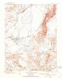
1908 Map of Carson Sink
USGS Topo · Published 1962About this map
Fallon serves as the hub of this early 20th-century desert landscape, where the Carson River feeds into the expansive Carson Sink and Carson Lake. This 1908 survey captures a critical period of western expansion, showing the Southern Pacific rail lines and the Nev and Cal RR connecting remote outposts like White Plains Huxley Sta and Jessup. The region's industrial footprint is prominently recorded through the Borax Works at Eightmile Flat and several high-elevation mining claims, including the Nevada Hills Mine near Fairview and the Desert Queen Mine in the Hot Springs Mountains. The map provides a detailed view of early water management and transportation, marking historical waypoints such as Ragtown and Frenchman Station along the vast alkali flats and mountain ranges.
Find a feature on this map
86 named features on this map. Tap any name to fly to it.
Don’t see what you’re looking for? This feature index may not catch every label — zoom into the map to look around manually.
Map Details
Editions of this 1908 Carson Sink Map
3 editions found

Other maps of this area

1886 · Granite Range
USGS Topo · 1:250,000

1890 · Wadsworth
USGS Topo · 1:125,000

1891 · Wabuska
USGS Topo · 1:125,000

1891 · Wellington
USGS Topo · 1:125,000

1892 · Wadsworth
USGS Topo · 1:125,000

1893 · Wellington
USGS Topo · 1:125,000

1894 · Granite Range
USGS Topo · 1:250,000

1894 · Wadsworth
USGS Topo · 1:125,000

1894 · Wabuska
USGS Topo · 1:125,000

1907 · Tonopah
USGS Topo · 1:250,000