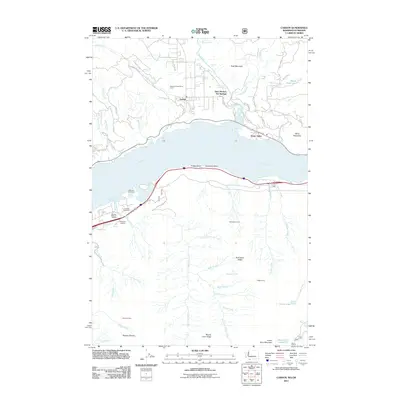
2011 Map of Carson
USGS Topo · Published 2011About this map
Saint Martins Hot Springs and the settlement of Carson anchor the northern banks of the Columbia River in this 2011 survey. The landscape is defined by the confluence of the Wind River and Little Wind River, where local industry and recreation intersect. Commercial activity is visible at the C L Lumber Company and the Ox Bow Salmon Hatchery, while the McQuinn Cemetery provides a point of genealogical interest near the river's edge. South of the river, the terrain rises sharply into the Benson Plateau and Nick Eaton Ridge, carved by numerous drainages such as Herman Creek and Gordan Creek. The map documents the persistent infrastructure of the Columbia River Gorge, from the northern rail lines through Home Valley to the southern routes passing Wyeth. This record captures the balance between established timber and fishing industries and the enduring natural features like Shepherd Falls and Wind Mountain.
Find a feature on this map
65 named features on this map. Tap any name to fly to it.
Don’t see what you’re looking for? This feature index may not catch every label — zoom into the map to look around manually.
Map Details
Editions of this 2011 Carson Map
This is the sole edition of this map. No revisions or reprints were ever made.
Other maps of this area

1926 · Hood River
USGS Topo · 1:125,000

1929 · Hood River
USGS Topo · 1:125,000

1953 · The Dalles
USGS Topo · 1:250,000

1956 · The Dalles
USGS Topo · 1:250,000

1957 · The Dalles
USGS Topo · 1:250,000

1957 · Bonneville Dam
USGS Topo · 1:62,500

1957 · Wind River
USGS Topo · 1:62,500

1957 · Willard
USGS Topo · 1:62,500

1957 · Hood River
USGS Topo · 1:62,500
1979 · Bonneville Dam
USGS Topo · 1:24,000