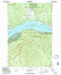
1994 Map of Carson
USGS Topo · Published 1996About this map
Columbia River serves as the central artery and dividing line between Washington and Oregon in this mid-1990s survey. The settlement of Carson sits north of the river, where Wind River and Little Wind River converge near the Shipherd Falls and a local Gaging Station. The landscape is defined by the steep elevation changes of the Columbia River Gorge National Scenic Area, with Buck Mtn and Wind Mtn overlooking the water.
Find a feature on this map
73 named features on this map. Tap any name to fly to it.
Don’t see what you’re looking for? This feature index may not catch every label — zoom into the map to look around manually.
Map Details
Editions of this 1994 Carson Map
This is the sole edition of this map. No revisions or reprints were ever made.
Other maps of this area

1926 · Hood River
USGS Topo · 1:125,000

1929 · Hood River
USGS Topo · 1:125,000

1953 · The Dalles
USGS Topo · 1:250,000

1956 · The Dalles
USGS Topo · 1:250,000

1957 · The Dalles
USGS Topo · 1:250,000

1957 · Bonneville Dam
USGS Topo · 1:62,500

1957 · Wind River
USGS Topo · 1:62,500

1957 · Willard
USGS Topo · 1:62,500

1957 · Hood River
USGS Topo · 1:62,500
1979 · Bonneville Dam
USGS Topo · 1:24,000