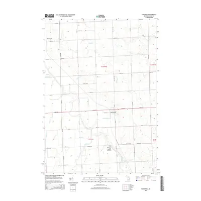
2014 Map of Carsonville
USGS Topo · Published 2014About this map
Carsonville serves as the central hub of this Sanilac County landscape, situated at the junction of E Sanilac Rd and Old 51. The surrounding area is defined by a dense network of agricultural drainage and small waterways, including the Black River and Elk Creek, which feed into the larger regional watershed. The map reveals a high concentration of historical burial sites that offer significant value for genealogical research, such as Washington Township Cem, Saint Marys Cem, and Lee Cem. To the northwest, the small settlement of McGregor marks the intersection of N Ruth Rd and Forester Rd. The terrain is characterized by its organized section lines and numerous named drains like Shrapnell Drain and Carsonville Drain, illustrating a long history of land management and rural development in this part of Michigan's Thumb region.
Find a feature on this map
56 named features on this map. Tap any name to fly to it.
Don’t see what you’re looking for? This feature index may not catch every label — zoom into the map to look around manually.
Map Details
Editions of this 2014 Carsonville Map
This is the sole edition of this map. No revisions or reprints were ever made.
Other maps of this area

1954 · Flint
USGS Topo · 1:250,000

1958 · Flint
USGS Topo · 1:250,000

1963 · Sandusky
USGS Topo · 1:24,000

1963 · Peck
USGS Topo · 1:24,000

1963 · Croswell
USGS Topo · 1:24,000

1963 · Port Sanilac
USGS Topo · 1:24,000

1963 · Palms
USGS Topo · 1:24,000

1963 · Applegate
USGS Topo · 1:24,000

1963 · Deckerville
USGS Topo · 1:24,000

1963 · Richmondville
USGS Topo · 1:24,000
Featured Places
- Carsonville, MI
- Washington Township, MI
- Forester Township, MI
- Watertown Township, MI
- Bridgehampton Township, MI