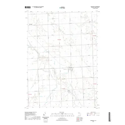
2019 Map of Carsonville
USGS Topo · Published 2019About this map
The village of Carsonville sits at the heart of this Sanilac County landscape, where the agricultural grid is intersected by the meandering course of the Black River and Elk Creek. This 2019 survey documents a region defined by its drainage network and rural cemeteries, reflecting generations of settlement in the Michigan Thumb. The village layout is concentrated along E Sanilac Rd and S Main St, while the surrounding townships of Washington and Bridgehampton are marked by several historic burial grounds, including Mount Zion Cem, Saint Marys Cem, and Washington Township Cem. To the northwest, the small community of McGregor is situated near Forester Rd. The map details an extensive system of waterways, from the Ogden Norton Drain to Sherman Cr and Miller Cr, which have long supported the local farming economy by managing the flat, fertile terrain of the area.
Find a feature on this map
68 named features on this map. Tap any name to fly to it.
Don’t see what you’re looking for? This feature index may not catch every label — zoom into the map to look around manually.
Map Details
Editions of this 2019 Carsonville Map
This is the sole edition of this map. No revisions or reprints were ever made.
Other maps of this area

1954 · Flint
USGS Topo · 1:250,000

1958 · Flint
USGS Topo · 1:250,000

1963 · Sandusky
USGS Topo · 1:24,000

1963 · Peck
USGS Topo · 1:24,000

1963 · Croswell
USGS Topo · 1:24,000

1963 · Port Sanilac
USGS Topo · 1:24,000

1963 · Palms
USGS Topo · 1:24,000

1963 · Applegate
USGS Topo · 1:24,000

1963 · Deckerville
USGS Topo · 1:24,000

1963 · Richmondville
USGS Topo · 1:24,000
Featured Places
- Carsonville, MI
- Washington Township, MI
- Forester Township, MI
- Watertown Township, MI
- Bridgehampton Township, MI