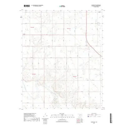
2018 Map of Carter East
USGS Topo · Published 2018About this map
Poarch Cem sits near the crossing of E 1250 RD in a region defined by the winding course of the North Fork Red River in Beckham County. This area of Oklahoma is characterized by its systematic section line road network, including arterial routes like e1240 and e1270 RD, which stitch together the small settlements of Carter and Taylor. The landscape is etched by a series of drainage systems, notably Boggy Cr, Sadler Cr, and Flat Cr, which flow toward the larger river basin in the south. The proximity of these watercourses to the road grid illustrates the historical challenge of navigating the region's low-lying drainage areas, while the presence of local landmarks like the cemetery provides a fixed point of reference for family history researchers tracking early western Oklahoma residents.
Find a feature on this map
22 named features on this map. Tap any name to fly to it.
Don’t see what you’re looking for? This feature index may not catch every label — zoom into the map to look around manually.
Map Details
Editions of this 2018 Carter East Map
This is the sole edition of this map. No revisions or reprints were ever made.
Other maps of this area

1955 · Clinton
USGS Topo · 1:250,000

1957 · Clinton
USGS Topo · 1:250,000

1960 · Sayre
USGS Topo · 1:62,500

1961 · Willow
USGS Topo · 1:62,500

1961 · Retrop
USGS Topo · 1:62,500

1961 · Elk City
USGS Topo · 1:62,500

1985 · Elk City
USGS Topo · 1:100,000
1987 · Hocker
USGS Topo · 1:24,000
1987 · Elk City SE
USGS Topo · 1:24,000
1989 · Willow
USGS Topo · 1:24,000