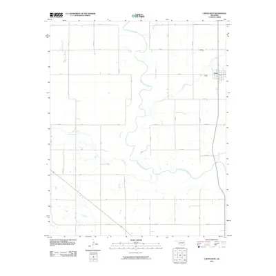
2010 Map of Carter West
USGS Topo · Published 2010About this map
The settlement of Carter stands at the eastern edge of this Beckham County landscape, where the town's street grid meets the open agricultural plains of western Oklahoma. This 2010 survey illustrates a highly structured section-line road system, including E 1230 Rd and N 1940 Rd, which segments the territory into distinct blocks used for ranching and farming. Winding through these rectilinear boundaries is the North Fork Red River, which meanders across the center of the sheet and is joined by several tributaries such as Flat Creek and Spring Creek. Just northwest of the town center, the Carter Cemetery provides a significant touchstone for genealogical research and local history. The map also records numerous specific survey blocks, labeled with identifiers like BK W and BK Z, reflecting the meticulous land management and surveying history of the Oklahoma territory.
Find a feature on this map
36 named features on this map. Tap any name to fly to it.
Don’t see what you’re looking for? This feature index may not catch every label — zoom into the map to look around manually.
Map Details
Editions of this 2010 Carter West Map
This is the sole edition of this map. No revisions or reprints were ever made.
Other maps of this area

1955 · Clinton
USGS Topo · 1:250,000

1957 · Clinton
USGS Topo · 1:250,000

1960 · Sayre
USGS Topo · 1:62,500

1961 · Willow
USGS Topo · 1:62,500

1961 · Retrop
USGS Topo · 1:62,500

1961 · Elk City
USGS Topo · 1:62,500

1985 · Elk City
USGS Topo · 1:100,000
1987 · Hocker
USGS Topo · 1:24,000
1989 · Willow
USGS Topo · 1:24,000
1989 · Carter West
USGS Topo · 1:24,000