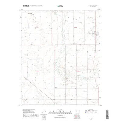
2018 Map of Carter West
USGS Topo · Published 2018About this map
The North Fork Red River meanders southward through the center of this Oklahoma landscape, carving a wide path between the agricultural townships of t9n r23w and t9n r22w. To the northeast, the small community of Carter is established on a grid of streets including Main St and Madison Ave, adjacent to the Carter Cem. The surrounding territory is defined by a systematic network of section-line roads, such as E1230 Rd and E1240 Rd, which provide access to rural homesteads and several significant tributaries.
Find a feature on this map
26 named features on this map. Tap any name to fly to it.
Don’t see what you’re looking for? This feature index may not catch every label — zoom into the map to look around manually.
Map Details
Editions of this 2018 Carter West Map
This is the sole edition of this map. No revisions or reprints were ever made.
Other maps of this area

1955 · Clinton
USGS Topo · 1:250,000

1957 · Clinton
USGS Topo · 1:250,000

1960 · Sayre
USGS Topo · 1:62,500

1961 · Willow
USGS Topo · 1:62,500

1961 · Retrop
USGS Topo · 1:62,500

1961 · Elk City
USGS Topo · 1:62,500

1985 · Elk City
USGS Topo · 1:100,000
1987 · Hocker
USGS Topo · 1:24,000
1989 · Willow
USGS Topo · 1:24,000
1989 · Carter West
USGS Topo · 1:24,000