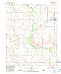
1989 Map of Carter West
USGS Topo · Published 1989About this map
The North Fork Red River snakes through this Beckham County landscape, defining the topography of the western Oklahoma plains in the late twentieth century. Centered around the town of Carter, the map illustrates a rural economy transitioning between traditional agriculture and modern energy infrastructure. A large Gas Storage Area and a complex Pipeline network dominate the northern and western sections, while the local community remains anchored by landmarks like Carter Cem and the Spring Creek Ch. To the south, the terrain known as Bettina is dissected by several watercourses, including Indian Creek, Flat Creek, and Boggy Creek. Evidence of earlier transport is visible in the Old Grade that parallels the modern rail line, offering a clear record of how the local transportation network evolved over several decades of field checks and aerial revisions.
Find a feature on this map
16 named features on this map. Tap any name to fly to it.
Don’t see what you’re looking for? This feature index may not catch every label — zoom into the map to look around manually.
Map Details
Editions of this 1989 Carter West Map
This is the sole edition of this map. No revisions or reprints were ever made.
Other maps of this area

1955 · Clinton
USGS Topo · 1:250,000

1957 · Clinton
USGS Topo · 1:250,000

1960 · Sayre
USGS Topo · 1:62,500

1961 · Willow
USGS Topo · 1:62,500

1961 · Retrop
USGS Topo · 1:62,500

1961 · Elk City
USGS Topo · 1:62,500

1985 · Elk City
USGS Topo · 1:100,000
1987 · Hocker
USGS Topo · 1:24,000
1989 · Willow
USGS Topo · 1:24,000
1989 · Delhi
USGS Topo · 1:24,000