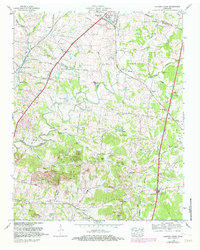
1965 Map of Carters Creek
USGS Topo · Published 1982About this map
Spring Hill and its surrounding pastoral landscape are anchored by the Tennessee Orphans Home and the Middle Tennessee Agricultural Experiment Station, reflecting a community centered on institutional care and agricultural research. The Louisville and Nashville railroad runs alongside the Andrew Jackson Highway, bisecting the landscape of rolling hills like Hicks Hill and Allen Hill. This 1965 survey (updated in 1982) details a region dense with small rural settlements like Neapolis and Kedron, where life revolved around local landmarks like the Old Brick Church and Lanton Church. Numerous family burial grounds, including the Campbell Cem and Dobbins Cem, are scattered across the watershed of Rutherford Creek, offering a detailed record for genealogists. The presence of strip mines in the northern reaches near Kleburne hints at the industrial activities that shaped the local economy alongside the traditional dairy and crop farming.
Find a feature on this map
92 named features on this map. Tap any name to fly to it.
Don’t see what you’re looking for? This feature index may not catch every label — zoom into the map to look around manually.
Map Details
Editions of this 1965 Carters Creek Map
2 editions found
Other maps of this area

1901 · Colombia
USGS Topo · 1:125,000

1909 · Franklin
USGS Topo · 1:62,500

1936 · Godwin
USGS Topo · 1:24,000

1936 · Verona
USGS Topo · 1:24,000

1936 · Rally Hill
USGS Topo · 1:24,000

1936 · Spring Hill
USGS Topo · 1:24,000

1936 · Theta
USGS Topo · 1:24,000

1936 · Carters Creek
USGS Topo · 1:24,000

1936 · Glendale
USGS Topo · 1:24,000

1936 · Columbia
USGS Topo · 1:24,000