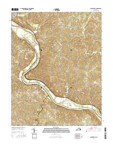
2016 Map of Cartersville
USGS Topo · Published 2016About this map
James River bends sharply through the heart of this Virginia landscape, serving as the historical dividing line between Goochland, Cumberland, and Powhatan counties. The river valley is punctuated by significant landforms such as Elk Island and Bolling Island, while the surrounding terrain rises toward Tamworth Bluff. The settlement pattern reflects the area's rural roots, with established communities like Cartersville and Tamworth positioned near the water, while upland hamlets such as Georges Tavern and Fife serve the interior.
Find a feature on this map
76 named features on this map. Tap any name to fly to it.
Don’t see what you’re looking for? This feature index may not catch every label — zoom into the map to look around manually.
Map Details
Editions of this 2016 Cartersville Map
This is the sole edition of this map. No revisions or reprints were ever made.
Other maps of this area

1890 · Goochland
USGS Topo · 1:125,000

1891 · Palmyra
USGS Topo · 1:125,000

1892 · Goochland
USGS Topo · 1:125,000

1895 · Palmyra
USGS Topo · 1:125,000

1897 · Palmyra
USGS Topo · 1:125,000

1943 · Goochland
USGS Topo · 1:31,680

1943 · Powhatan
USGS Topo · 1:31,680

1943 · South Anna
USGS Topo · 1:24,000

1943 · Richmond
USGS Topo · 1:250,000
1944 · South Anna
USGS Topo · 1:31,680