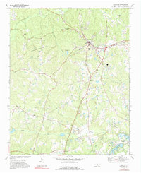
1974 Map of Carthage
USGS Topo · Published 1992About this map
Carthage serves as the focal point of this Moore County landscape, where the town's grid meets a network of country roads leading to outlying settlements like Pleasantville and Eastwood. The 1970s terrain is defined by its social institutions, including the County Sch and several local congregations such as Bethlehem Ch, Mt Olive Ch, and St Johns Ch. To the west, the expansive Goodwin State Forest covers a large tract of woodland, while the south and east transitions into a more developed recreation-focused area. This shift is visible in the emergence of Whispering Pines, characterized by Spring Valley Lake, Thagards Lake, and multiple golf courses. For genealogists, the map identifies numerous family and community landmarks, from Priest Hill Ch to various Cemeteries scattered along the drainages of McLendons Creek and the Little River.
Find a feature on this map
34 named features on this map. Tap any name to fly to it.
Don’t see what you’re looking for? This feature index may not catch every label — zoom into the map to look around manually.
Map Details
Editions of this 1974 Carthage Map
2 editions found
Other maps of this area

1942 · Troy
USGS Topo · 1:125,000

1948 · Southern Pines
USGS Topo · 1:62,500

1949 · West End
USGS Topo · 1:24,000

1949 · Jackson Springs
USGS Topo · 1:62,500

1950 · Niagara
USGS Topo · 1:24,000

1950 · Southern Pines
USGS Topo · 1:24,000

1953 · Raleigh
USGS Topo · 1:250,000

1954 · Raleigh
USGS Topo · 1:250,000

1957 · Southern Pines
USGS Topo · 1:62,500
1957 · Southern Pines
USGS Topo · 1:24,000