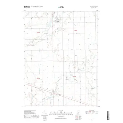
2019 Map of Carthage
USGS Topo · Published 2019About this map
The Big Blue River and Little Blue River define the agricultural landscape of northern Rush County, where the town of Carthage sits at a historic crossing point. This area is characterized by a dense network of drainage ditches and brooks, such as Newhouse Ditch and Stanley Brook, which supported the conversion of this terrain into productive farmland. The settlement of Arlington serves as a southern anchor for the quadrangle, positioned near East Hill Cem.
Find a feature on this map
70 named features on this map. Tap any name to fly to it.
Don’t see what you’re looking for? This feature index may not catch every label — zoom into the map to look around manually.
Map Details
Editions of this 2019 Carthage Map
This is the sole edition of this map. No revisions or reprints were ever made.
Other maps of this area

1950 · Dunreith
USGS Topo · 1:24,000

1953 · Cincinnati
USGS Topo · 1:250,000

1956 · Cleveland
USGS Topo · 1:24,000

1956 · Morristown
USGS Topo · 1:24,000

1956 · Rays Crossing
USGS Topo · 1:24,000

1957 · Cincinnati
USGS Topo · 1:250,000

1959 · Rushville
USGS Topo · 1:24,000

1959 · Mays
USGS Topo · 1:24,000
1960 · Manilla
USGS Topo · 1:24,000
1960 · Carthage
USGS Topo · 1:24,000