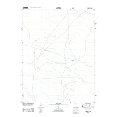
2011 Map of Carvers SE
USGS Topo · Published 2011About this map
Gold Hill Mill sits as a remnant of industrial activity in the central Nevada landscape, marking a site of resource extraction in Nye County. The terrain is defined by a network of drainage systems including Barker Creek, Willow Creek, and Jefferson Creek, which flow through the high desert environment. Infrastructure is sparse, characterized by utility roads such as Berg Fenceline Rd and Dump Rd, alongside the Barker Creek Ranch Airstrip. This 2011 survey by the U.S. Geological Survey illustrates the intersection of ranching and mining history, where name-bearing landmarks like Anderson Creek and Moores Creek delineate the watershed. The presence of the Nfd 158 Rd indicates access into the surrounding forest service lands, connecting these remote outposts to the wider region.
Find a feature on this map
11 named features on this map. Tap any name to fly to it.
Don’t see what you’re looking for? This feature index may not catch every label — zoom into the map to look around manually.
Map Details
Editions of this 2011 Carvers SE Map
This is the sole edition of this map. No revisions or reprints were ever made.
Other maps of this area

1907 · Tonopah
USGS Topo · 1:250,000

1908 · Tonopah
USGS Topo · 1:250,000

1956 · Tonopah
USGS Topo · 1:250,000

1959 · Tonopah
USGS Topo · 1:250,000

1962 · Tonopah
USGS Topo · 1:250,000

1971 · Carvers NW
USGS Topo · 1:24,000

1971 · Carvers
USGS Topo · 1:24,000
1971 · Jet Spring
USGS Topo · 1:24,000

1971 · Pablo Canyon Ranch
USGS Topo · 1:24,000
1971 · Carvers NE
USGS Topo · 1:24,000